
Topographic Survey of Barranco de Lermes
- Aug 11, 2025
- 2 min read
At Digital Fiber Planners S.L., we have completed a topographic survey in the Barranco de Lermes, Tenerife, using an innovative approach that combines aerial photogrammetry with a drone and GNSS positioning in RTK mode.
The main objective: to generate a high-precision Digital Elevation Model (DEM) for the production of contour lines and cross-sectional profiles.
Objective of the Topographic Survey
The goal was to obtain a DEM with centimeter-level accuracy, optimizing work time and avoiding flying over private areas. To achieve this, data collection was divided into two phases:
Complete aerial coverage of the Barranco de Lermes using a drone.
Elevation survey of the nearby road using GPS.

Location
The survey was carried out in Barranco de Lermes, with access via Calle el Hibisco, in the municipality of Los Gigantes, on the island of Tenerife. The surroundings combine urban and tourist areas, featuring residential and hotel buildings.

Equipment Used
To ensure maximum accuracy and data quality, we used:
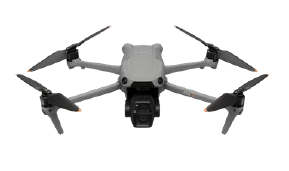
Dron DJI Air 3S: Main 1-inch CMOS camera with 50 MP resolution, equipped with 360° obstacle avoidance sensors.
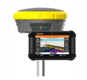
GPS GEOMAX Zenith 60 IMU: High-precision real-time GNSS RTK receiver.
Methodology
We integrated GNSS RTK and aerial photogrammetry into a coordinated workflow:
Establishment of Ground Control Points (GCPs) using GNSS RTK to georeference the model.
Planned drone flight ensuring optimal longitudinal and lateral overlap.
Photogrammetric processing to generate a dense and georeferenced point cloud.
Vegetation filtering to obtain contour lines representing only the terrain morphology.
Generation of the Digital Elevation Model (DEM) and deliverables: contour lines, cross-sectional profiles, and CAD-format plans.
Results
Root Mean Square Error (RMSE): 0.02 m (2 cm), confirming centimeter-level accuracy.
Resolution: 3 cm/pixel.
Deliverables:
DEM with and without vegetation.
Filtered contour lines in .dwg format.
Cross-sectional profiles.
Plan with smoothed contour lines.


Conclusion
The synergy between GNSS RTK and aerial photogrammetry allowed us to obtain a reliable and precise topographic model. This methodology is ideal for civil engineering projects, urban planning, and environmental impact studies, where accuracy in terrain representation is crucial.

At Digital Fibers Planners S.L., we continue to invest in cutting-edge technology to deliver fast, precise results tailored to each project.


